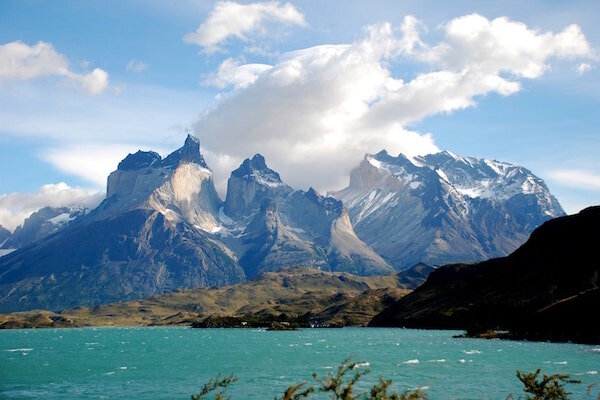
Where and what is The Patagonia?
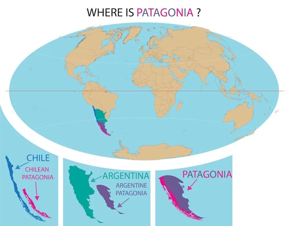
Patagonia is neither a nation nor a specific province but is a region comprising of all southerly Chile and Argentina.
How big is Patagonia?
Is Patagonia big? Patagonia is 347,627 square miles. Approximately twice the size of Italy.
This makes Patagonia larger than over 80% of the nations of the world.
where exactly is “the Patagonia”?
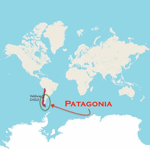
Patagonia is one of the most famous places in the world, yet no two people can seem to agree where it starts.
What are the boundaries of this famed spot?
Finding a definite area has been a challenge. But after weeks of research, this riddle has been solved. The rest of this article follows my journey to discovering the boundaries of South America’s Patagonia.
commonly accepted boundaries of patagonia

A simple Google search will turn up just as many answers as results. Most Chileans say south of Puerto Montt (textbooks in Chile teach this). Many Argentinians will say everything past Bariloche.
With all the confusion I decided to contact some experts. I reached out to the Chilean and Argentinian governments. The Embassy of Argentina said, “it’s a geographic region and not a defined province of Argentina.” I basically got the same response from the Chilean government. Was this a diplomatic answer from politicians?
Next, I emailed GoChile, which is the largest travel website in Chile. GoChile says:
“La patagonia esta al sur de Chile y Argentina.”
This roughly translates to:
“The Patagonia is in the South of Chile and Argentina.”
Was this helpful??? Maybe. This is the same response I got from both government offices.
wikipedia’s definition of Patagonia
Next stop…..Wikipedia…….Wikipedia says Patagonia is the “region at the southern end of South America shared by Argentina and Chile”.
Wikipedia defines the boundaries as:
The Pacific Ocean to the west
The Atlantic Ocean on the east
Southern border: Straight of Megellan, the Beagle Channel and the Drake Passage
Northern limit:
Colorado & Barrancas River in Argentina
Huincul Fault in Araucania Region
To simplify this for people that are unfamiliar with these places. Wikipedia is basically saying:
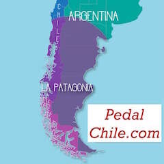
The Chilean Patagonia goes from Temuco to the tip of South America
The Argentinian Patagonia is everything south of Neuquén
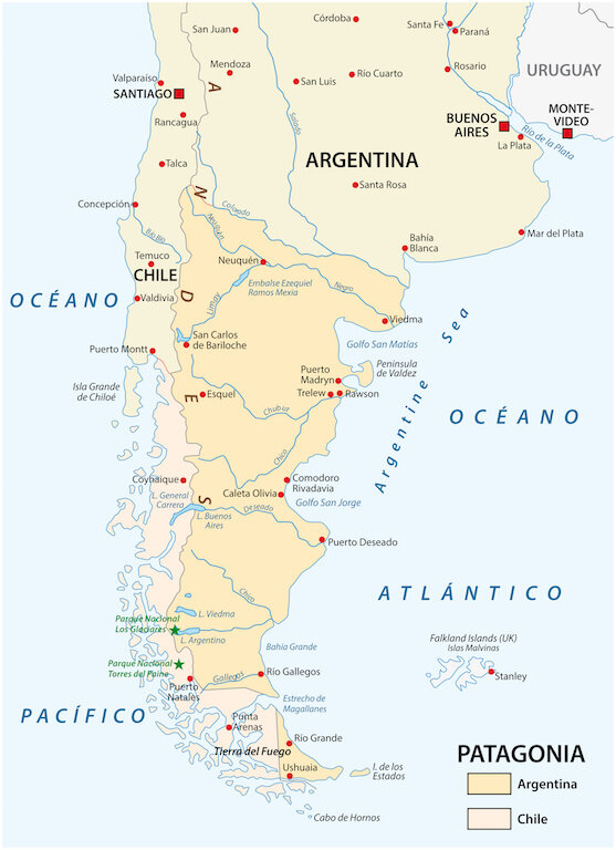
This map is the commonly accepted area of Patagonia
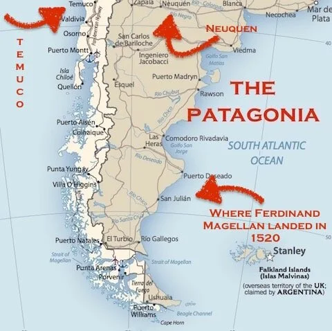
Northern limit of Patagonia
The Colorado River valley and Barrancas River, which reach the Atlantic Ocean about 50 miles south of Bahia Blanca. This natural river border is commonly considered the northern limit of the Argentinian Patagonia. Neuquén, which is the largest “commonly” accepted city in this sector has a current population of around 340,000 people.
Temuco, which some maps show as the largest city on the Chilean side, has a population of approximately 220,000 people. These two cities house over a half million people in what could more accurately be described as a concrete oasis.
Neither one of these cities would ever be confused as the Patagonian entry point in their respective countries. Read any guidebook to Argentinian Patagonia and none of them will suggest Neuquén. Some will recommend Puerto Madryn or San Carlos de Bariloche for entry to the northern section.

Researching patagonia at the library
After getting no clearly defined areas from both governments, I decided to do some research at the library.
In the book Geografia Historica de la Patagonia (The Historical Geography of the Patagonia) noted Argentinian historian Raúl Rey Balmaceda says:
“If we look at a map of South America, we can note that the region designated with the name Patagonia covers the narrow strip on the Chilean coastline south of Valdivia, the Patagonian Mountains, and the ledges and terraces that descend from them towards the Atlantic Ocean” - Raúl Rey Balmaceda
Enrique Campos Menéndez, from his book, The Soul of Patagoina, says:
“39° and 59° of southern latitude in South America, made up by one million square meters of mainland territory and surrounded by two great oceans - the Atlantic and the Pacific - and an archipelago of channels and fjords that make up the bottom cone of the continent.” - Enrique Campos Menéndez - Chilean Writer (el Ama de la Patagonia)
“The name Patagonia is here applied to the country extending from the line of the Rio Negro, about latitude 40° south, to the Straits of Magellan; and is bounded on the east by the Atlantic Ocean”
39° degrees latitude & northern limit
Where is 39° degrees latitude?
Valdivia in Chile and Neuquén in Argentina (the northern limit).
What about 59° or the southern limit?
59° is the southern latitude coordinate for the Drake Passage.
This passage connects the Pacific to the Atlantic Ocean.
All these historians agree, but maybe they just agree from years of studying the same outdated maps?

Drake Passage at 59 degrees South Latitude
“Historically, the traditional boundaries of Patagonia are well known, but the subject continues to be debatable considering recent archaeological discoveries and the availability of more in-depth and widely publicized investigation in modern times ”

border disputes
Author Jaime Said is 100 percent correct. Look at any map that predates the independence of Chile and Argentina and it has clear and defined borders. The issue got complicated once Chile and Argentina started to explore the region shortly after they both achieved independence.
The first treaty that focused on the border issue was signed in 1856. The issue now became what country was Patagonia in. Even today, looking at local maps of the southern Patagonian area, one will find places that both countries claim. Los Glaciares National Park is an interesting example.
The borders have been fought over for years. The main issue is related to WATER.
“The vital natural resources located in these glaciers, which is key to the development of people’s lives, both for daily consumption and the economic activities of such great importance on the eastern side, such as agriculture and livestock”

Los glaciares National Park - Argentinian Patagonia.
After hours of research, emailing, and scouring the web, I finally stumbled upon a brochure from Parque Patagonia. The following quote is taken directly from this brochure.
“The name “Patagonia” evokes images
of a wild, untamed place, but drawing the exact borders of Patagonia is a challenge. It is neither its own nation nor a specific province but in general has come to mean the region comprising all of southerly Chile and Argentina.”
political region
The governments of Chile, Argentina, and the GoChile website were exactly right. For both Argentina and Chile, Patagonia is not a single providence or county and only came to be regarded as a political region during the last century. Since Patagonia is located in both Argentina and Chile it has no provincial or territorial ownership.
To say the borders are irreverent would be naive, considering border disputes have been ongoing since the 1850s. The average person has heard of Patagonia but placing it on a map would prove to be a challenge.….just point to the far south of South America and you will be correct.
Image Source: Wikimedia Commons
what is the origin of the word patagonia?
This origin story has several different versions. The simplest version is generally the correct one. In 1520 Ferdinand Magellan landed in what is now Puerto San Julián, Argentina. At the time a book called Primaleon was very popular.
This book (the Spanish edition was printed in 1512), featured a race of wild people called the Patagonians. In the book, the hero Primaleon sails off to a faraway land. The natives in this “new” land eat raw flesh and wear animal skins.
This sounds almost identical to the tales that were told years later. Magellan encounters a group of natives and their natural way of living. The fantastical novel resurfaces in his mind, and we now have a real-life Patagonia.
For an in-depth look at the origins of the word ‘Patagonia,’ check out my article on the place-name history of ‘La Patagonia’

Jesse is Director of Pedal Chile and lives in Valdivia, Chile (most of the year). Pedal Chile is an all-inclusive mountain bike tour company based in Chilean Patagonia. Jesse is an avid MTBer, snowboarder, non-fiction reader, and blogger.


Sources for this article:
“Argentina - the World Factbook.” Www.cia.gov, www.cia.gov/the-world-factbook/countries/argentina/.
“Chile - the World Factbook.” Www.cia.gov, www.cia.gov/the-world-factbook/countries/chile/.
Holz, Andrés, et al. “Fires: The Main Human Impact on Past Environments in Patagonia?” Past Global Change Magazine, vol. 24, no. 2, Dec. 2016, pp. 72–73, 10.22498/pages.24.2.72.
Lieutenant Musters (1872). On the Races of Patagonia. The Journal of the Anthropological Institute of Great Britain and Ireland, Vol. 1, pp. 193-207.
Manzano Iturra, Karen Isabel. "Representaciones geopolíticas: Chile y Argentina en Campos de Hielo Sur." Estudios Fronterizos, vol. 17, no. 33, 2016, p. 83+. Gale OneFile: Informe Académico, Accessed 6 Jan. 2020. Link
“Patagonia.” Wikipedia, 19 Jan. 2021, simple.wikipedia.org/wiki/Patagonia.
Said, J. (2014). Patagonia. Penguin Random House Grupo Editorial Chile.
Webb, Kempton E, and Emilio Fernando. “Patagonia | Map & Facts.” Encyclopædia Britannica, 26 Oct. 2018, www.britannica.com/place/Patagonia-region-Argentina.